Explore the Mesonet
Below is an interactive map of current conditions at the Montana Mesonet Stations. A full-page version of the map is available at https://mesonet.climate.umt.edu/api/v2/map/latest/ Change the variable by clicking on the variable name in the legend.
Mesonet Photo Explorer
The Mesonet Photo Explorer is an interactive tool for viewing and downloading the full archive of photos taken by the Montana Mesonet HydroMet stations. Each station is equipped with a pan-tilt-zoom camera that regularly photographs the surrounding landscape in all cardinal directions, toward the sky, and at the snowpack.
The Mesonet Photo Explorer is available at https://mesonet.climate.umt.edu/photos.
Background
The Montana Climate Office (MCO) installed 6 weather and soil moisture monitoring stations in 2016 as part of the Montana Research and Economic Development Initiative (MREDI). The Mesonet was designed to support decision-making for statewide drought assessments, precision agriculture and rangeland and forested watershed management. Since 2016 the network has grown to over 215 active stations through support from private landowners, watershed groups, tribes, state agencies and grants from federal entities. In 2020 the MCO was awarded a contract from the U.S. Army Corps to add 205 additional stations, of which 128 have been installed. The new stations will be installed every 500 square miles in central and eastern Montana to improve drought assessments and flood forecasting - in the protection of lives and property.
Mesonet Networks
The Montana Mesonet is comprised of two sub-networks of stations: the AgriMet and the HydroMet. The AgriMet network is focused on precision agricultural applications, while the HydroMet network is focused on hydrological and water management applications. Each network has its own set of stations, which use different sensors and data collection methods to provide the most relevant information for their respective applications. A summary of the station configurations for each network is provided below.
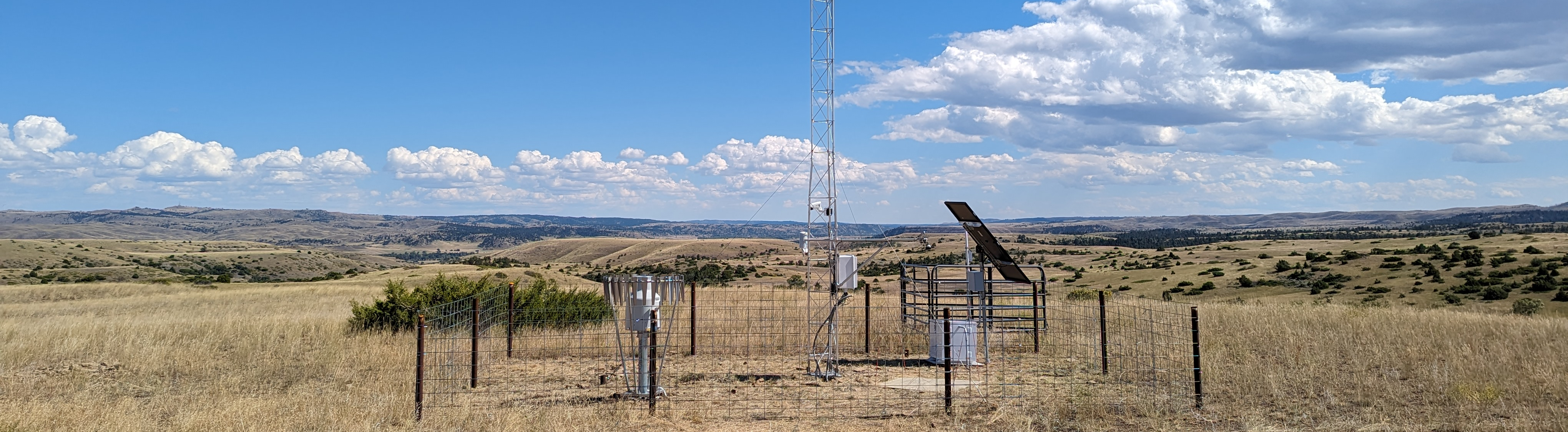
AgriMet Configuration
| Measurement | Height | Sensor | Accuracy |
|---|---|---|---|
| Barometric Pressure | - | ATMOS 41 | ±0.05 kPa at 25 °C |
| Air Temperature | 2m | ATMOS 41 | ±0.2 °C |
| Relative Humidity | 2m | ATMOS 41 | ± 1.5% to 2% |
| Solar Radiation | 2m | ATMOS 41 | ± 5% |
| Wind Speed | 2m | ATMOS 41 | ±0.3 m/s |
| Wind Direction | 2m | ATMOS 41 | ±5 ° |
| Rainfall | 2m | ATMOS 41 | ±5% |
| Soil Temperature | 10, 20, 50, 90 cm | TEROS 12 | ±0.3 °C |
| Soil Water Content | 10, 20, 50, 90 cm | TEROS 12 | ±0.03 m³/m³ |
Example photo of an AgriMet station:
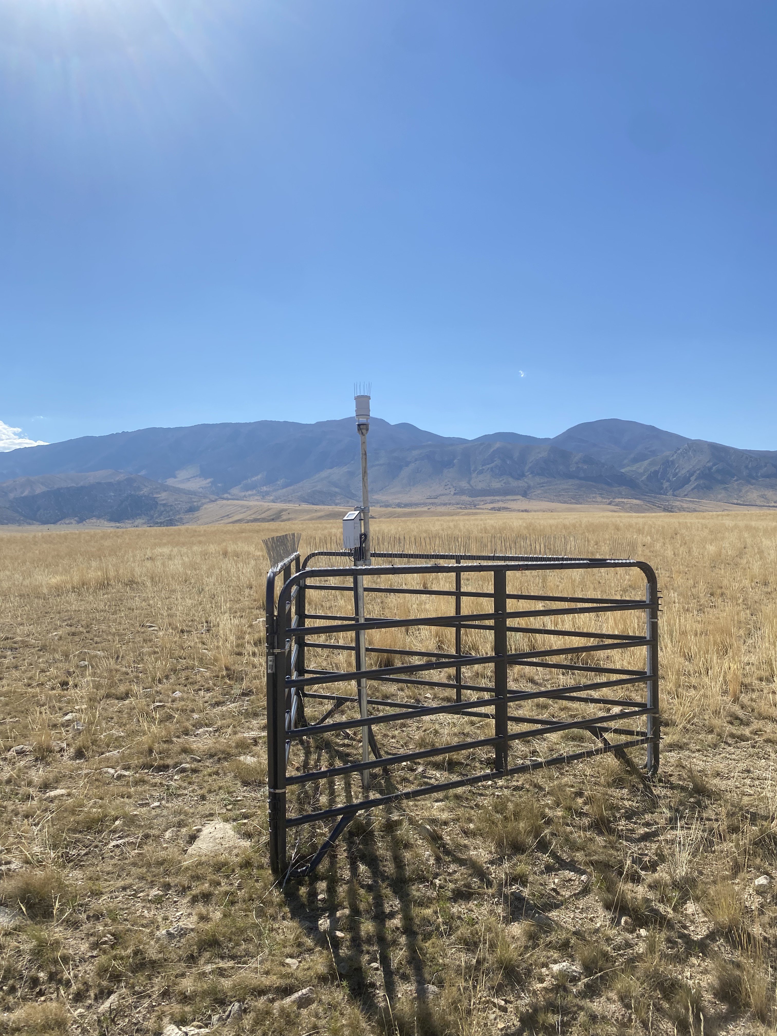
HydroMet Configuration
| Measurement | Height | Sensor | Accuracy |
|---|---|---|---|
| Barometric Pressure | - | Apogee SB110 | ± 1.5 % |
| Air Temperature | 2m | HMP155A | ±0.05 °C |
| Relative Humidity | 2m | HMP155A | ± 1.0% |
| Solar Radiation | 2m | Apogee SB510ss | < 3% |
| Wind Speed | 10m | RM Young 05108-74 | ±0.3 m/s |
| Wind Direction | 10m | RM Young 05108-74 | ±3 ° |
| Precipitation – rain & snow | 2m | Pluvio 2L | +/- 0.254 mm |
| Soil Temperature | -5, -10, -20, -50, -100 cm | Acclima TDR 310N | ±0.25 °C |
| Soil Water Content | -5, -10, -20, -50, -100 cm | Acclima TDR 310N | ±0.03 m³/m³ |
| Snow Depth | 2m | SnowVue10 | 0.2% |
| Photos | N, S, E, W, Ground | Pan, Tilt, Zoom Camera | - |
Example photo of a HydroMet station:
A Cooperative Framework
No one entity can ensure sustained operation and success of a statewide climate and soil moisture information network. With this in mind, the MCO embraces a cooperative context that addresses a diverse set of information needs. The MCO extends a significant cost reduction on science grade stations to cooperators and installs them as funds become available. The MCO continues to develop to ensure that data are quality controlled and accessible in real time through web services and smart devices. An annual service fee covers data transmission fees, computing infrastructure, and maintenance costs. Simply stated, the MCO will not profit from the stations or maintenance of the network beyond the inherent value in facilitating an expansive and publically available soil moisture and climate information network for Montanans.
Data Management
All stations are solar powered, and allow users to check the data from virtually anywhere in the world. Data are transmitted from the data-logger’s internal module to MCO’s secure server via cellular communication. Quality assurance and control checks are applied and the data are available to the user to access and monitor. Transmitted data are backed up in the data-logger’s memory and at the MCO to provide an extra layer of redundancy and protection.
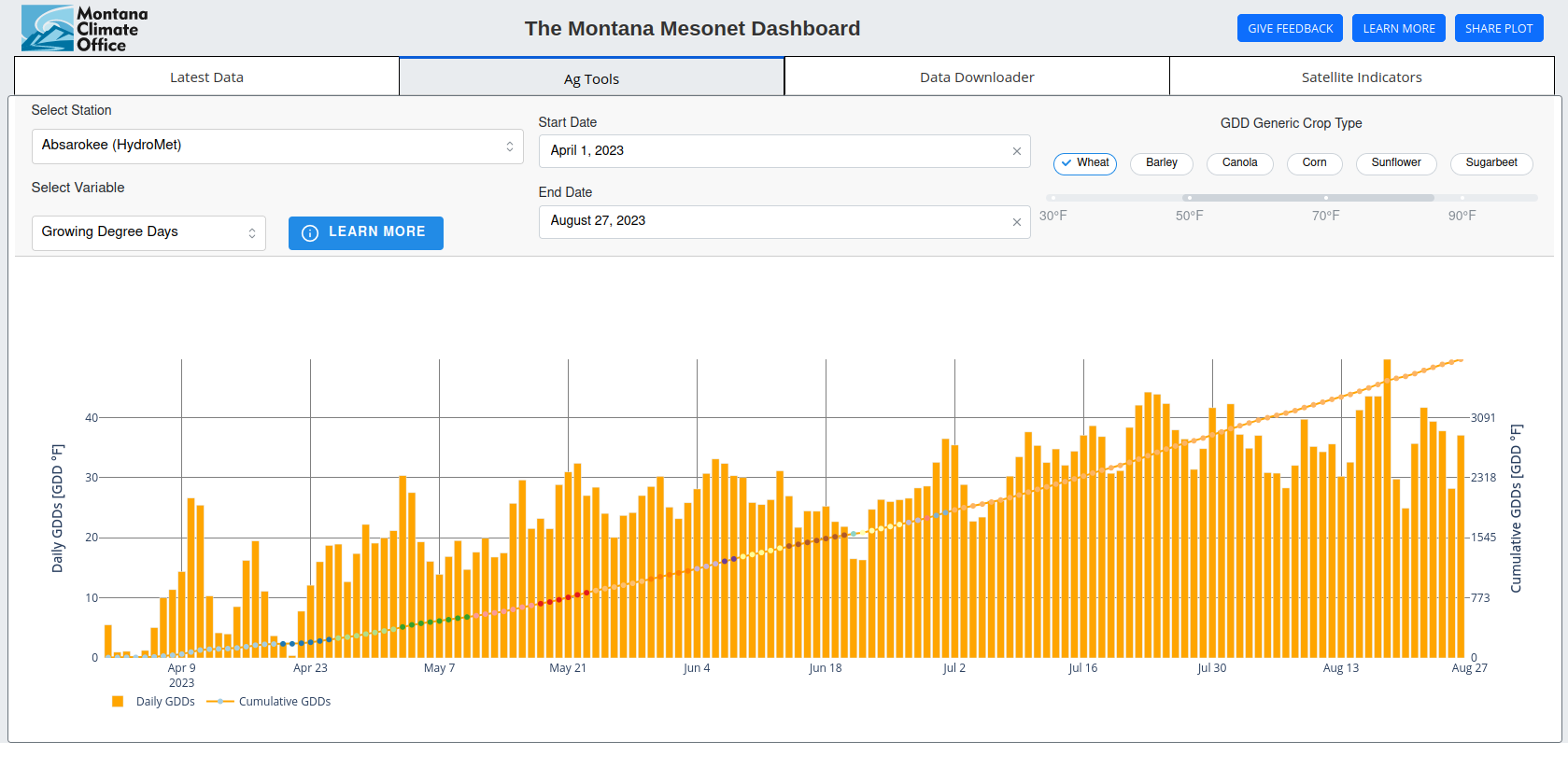
Use the Mesonet Dashboard
The Montana Mesonet Dashboard is a free, open source tool for plotting and analyzing the latest data from Montana Mesonet stations. The dashboard uses the Plotly Dash library to create interactive graphs on demand, displaying up to two weeks of data for a given mesonet station. The dashboard also allows users to compare station data to 30-year gridMET climate normals, download data, view derived agricultural metrics, and plot relevant satellite indicies against station data. For the full functionality of the dashboard, it is recommended to visit from a computer, but a mobile version with fewer features is also available. The code used to create the dashboard is publicly available at https://github.com/mt-climate-office/mesonet-dashboard. If you encounter any bugs, would like to request a new feature, or have a question regarding the dashboard, please:
- Email james.seielstad@mso.umt.edu,
- Fill out our feedback form,
- Or open an issue on our GitHub.