Significant May Precipitation Event
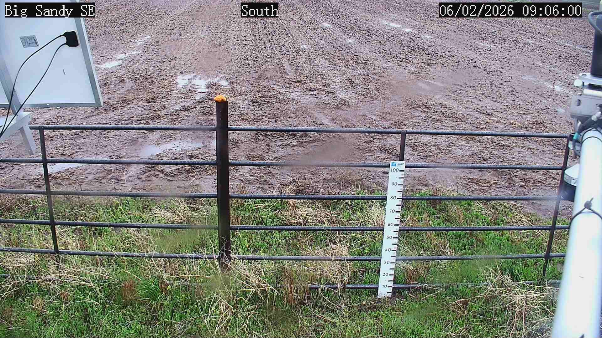 Photo of a muddy field at the Big Sandy SE Station on June 2nd.
The low-pressure storm system from May 30th to June 2nd produced record-breaking precipitation in multiple towns across Montana and delivered significant rain across most of the state.
This storm produced enough rain to significantly impact SPI and streamflows across the state, providing beneficial moisture into the system. The Montana Mesonet stations recorded this event, and the impacts of this weather system are explored below.
Precipitation Totals
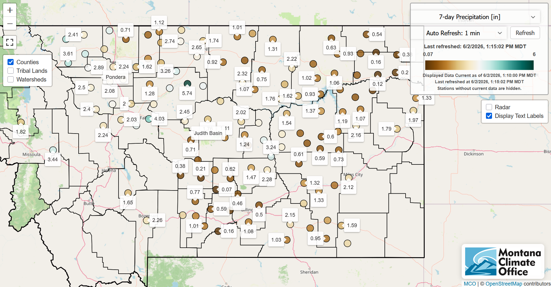
In the Northwest, the Flathead Valley, the Swan Range, and the Mission Mountains received upwards of 3-5+ inches of rain based on NWS reporting.
The central and southern part of the state received about 1–3 inches of rain, which will be beneficial for crop and pasture green up, replenishing stockponds, revitalizing streamflow, and improving soil moisture conditions. With the north central part of the state being in severe drought conditions, this storm provided much needed moisture.
The south-central and northeast parts of the state are the only areas that did not receive exceptionally high rainfall, with totals of 0.12 to less than an inch. With the northeastern part of the state in moderate-to-severe drought conditions and having already experienced a dust storm that eroded significant amounts of topsoil, this lack of precipitation will continue to exacerbate dry soil moisture conditions.
A few notable reports:
- Lubrecht station reported 3.44 inches of rain.
- Big Sandy SE picked up 5.74 inches of rain, north of Great Falls.
- 3.44 inches fell at the CSKT Bison Range.
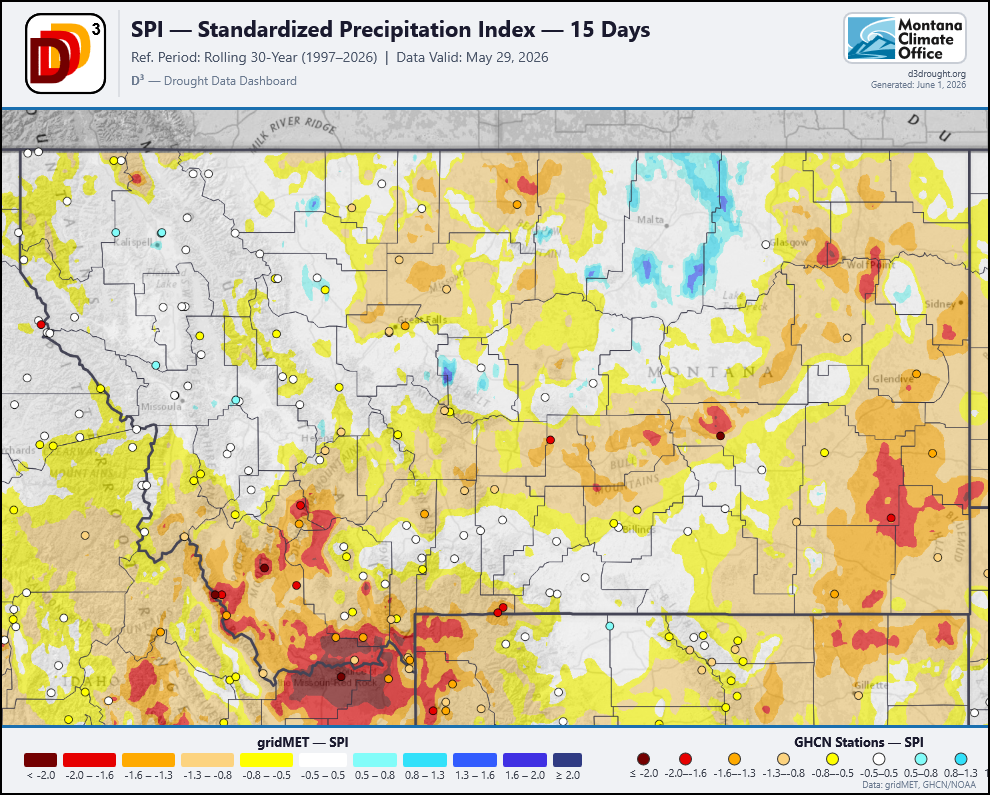
SPI Impacts
The Standardized Precipitation Index (SPI) measures precipitation anomalies relative to a long-term climatology. Negative values indicate drought conditions; positive values indicate wet conditions.
This section examines the storm’s impact on SPI (May 29 – June 2), showing changes in soil moisture as moisture infiltrates the ground.
Timescale: Looking at conditions over the last 15 & 30 days.
15 Day SPI
- Note: 15 day SPI lags a day
May 29th: Before the low pressure system rolled in.
May 30th: First day of significant rainfall.
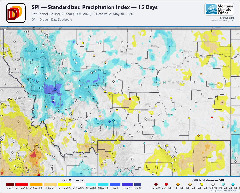
May 31st: Second day of significant rainfall.
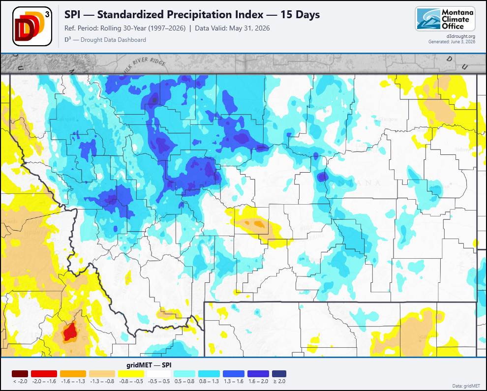
The 15-day SPI shows dramatic improvement from < -2.0 SPI conditions in the southeastern part of the state before the storm, which is in D3 conditions. The storm brought the surface soil moisture conditions into a (-0.5 – 0.5) normal range, which is very beneficial for this location, as they have received minimal precipitation over the last few months, and minimal snowpack. The SPI is capturing the high amounts of precipitation that the central part of the state received. This location is also in D3 conditions. This storm brought significant improvement for 15 day SPI in most of the state.
30 day SPI
May 30th: First day of significant rainfall
May 31st: Second day of significant rainfall.

June 1st: 3rd day of significant rainfall.
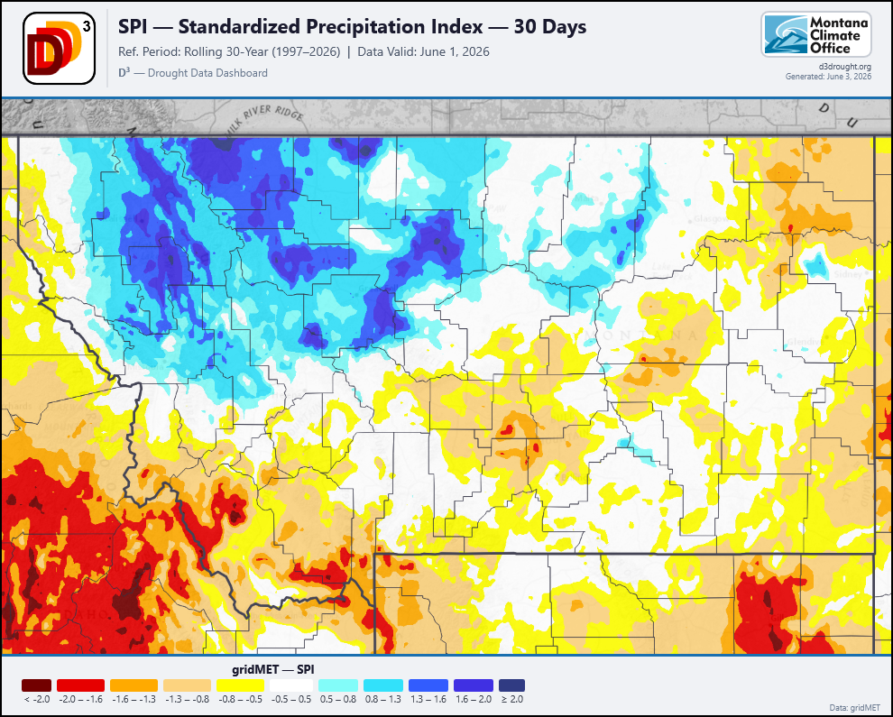
The 30-day SPI gives us additional context to the soil moisture conditions as the SPI was more resistant to change over this storm in the southeast and northeast. This gives an indication of how dry soil moisture conditions are in those parts of the state.
In line with the precipitation totals in the central part of the state is the significant departure from the historically average SPI for the month of May, and within two days it transitioned to completely above-normal SPI over 2.0 (dark blue). This sets the Golden Triangle up for soil moisture buffers for agricultural production, refilling stock ponds on cattle ranches, and reducing the need for irrigation at this time of year.
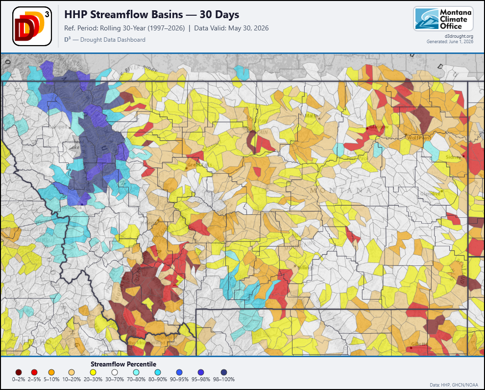
Streamflow
May 30th
.png)
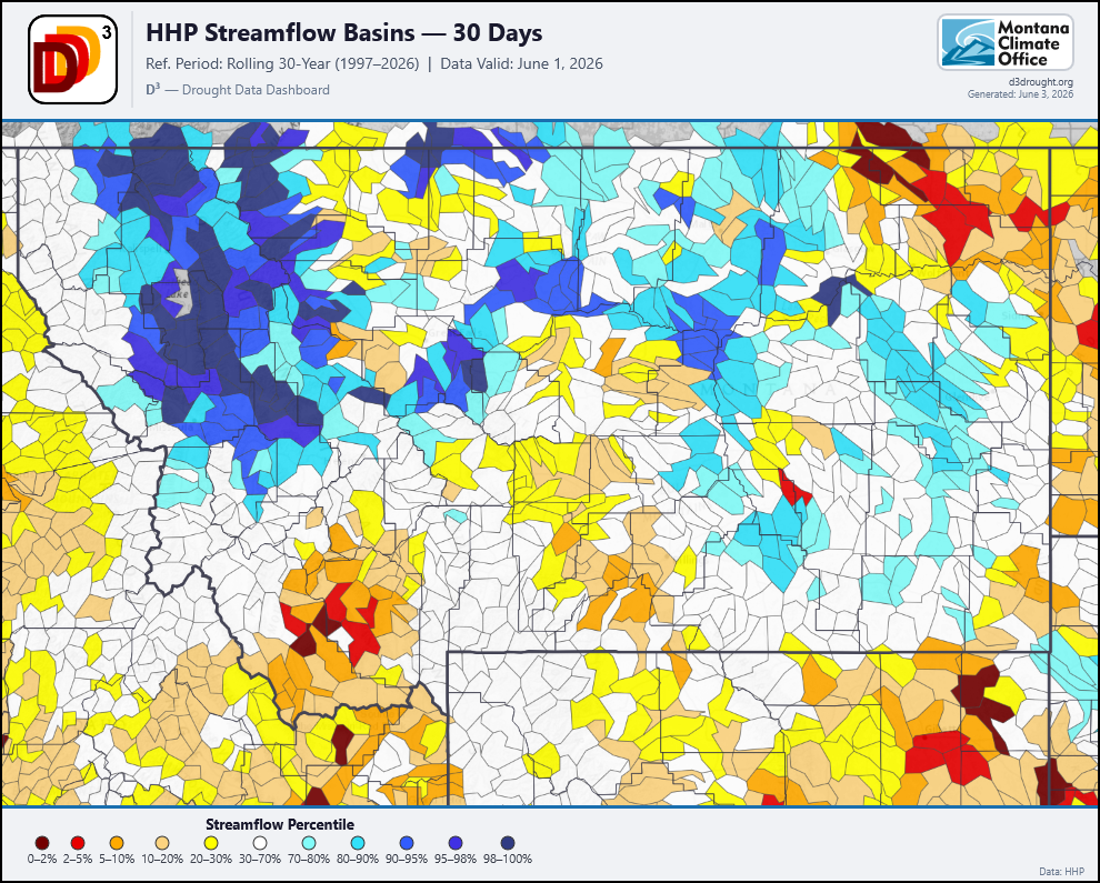
Using the Headwaters Hydrology Project Streamflow Model to visualize the impacts of this storm show that this event brought streamflows from below 30% and normal into the 80th, 90th, and 100th percentiles for this time of year. In the Flathead Valley, this resulted in a historic flooding event. Streams and rivers throughout the region shot up into minor flood stages and high flows from the precipitation that fell. This has brought rivers in the central parts of the state, who were at extremely low flows for this time of year back into normal, or even above-normal, ranges, benefiting ranchers, irrigation, and fisheries. The southern part of the state had some relief as basins moved from the lowest flows they have experienced to flows at the 10th-20th percentiles.
Overall Impacts
The impacts of this storm will vary across the state as the system interacts with conditions that have been occurring this spring. Overall, this storm brought significant and beneficial rain that will add to reservoir levels, improve soil moisture conditions for farmers, ranchers, and rangelands.